A day of rest—Archaeological aspirations—A ruined mission—The Kiliwa Indians—An aboriginal stronghold—Another parched walk—Water water everywhere—Fr. Baegert’s warning—A rephoto found!—Then lost—Then found!—Lessons learned—A landscape unaltered—Rephoto fun at camp–Further historical analogs
7 June, Camp, La Grulla, 6am
Today we hope for a short walk after yesterday’s death march. We’re all still reeling from the return trek. John and I set off for the meadow again in hopes of locating a re-shoot opportunity for Borell’s photo of the “former meadow” (4808)—the only one of La Grulla he left behind, but which we have yet to locate even after many days of meadow-gazing. We also hope to catch a glimpse of some ruins of an eighteenth-century Catholic mission here that we read about and whose whereabouts Don Rolando intimated he might know. The prospect of playing archaeologist excites John and me.

The history of settlement on the peninsula dates to the Catholic missionaries, whose earliest priests, the Jesuits, arrived in the late seventeenth century. The Jesuits, both Spanish and German, operated on the peninsula at the pleasure of the Spanish government, and as far as missionaries go, these were pretty benign. There were surprisingly few indigenous people here, and the lack of resources to build, combined with the severity of the climate, tempered grander aspirations. By 1758 there were but eight German and four Spanish missionaries in Lower California,” and “half that number would have been enough to take care of the spiritual needs of the Indians” (Brandenburg xiv). Missionaries to the peninsula—which they called “Old California” or simply “California”, making no distinction between alta and baja—would set off from mainland Mexico across the Gulf of Californiain wooden canoes. The German Jesuit Johann Jakob Baegert described making the crossing in 1751 in “a hollow tree” or “small boat of one piece” [Baegert 11]). The journey took two days. Missionary life in Baja was beset with difficulties, to say the least, and Fr. Baegert’s account contains detailed accounts of many of them. But far from deterred, missionaries continued to operate here until they were forcibly expelled by the Spanish government in in 1767, which replaced them with Dominicans and Franciscans. By then, they had turned hardship into a vocation: “Just because Indians are less numerous, they must not be left helpless,” he wrote. “The more forsaken a people is, the more miserable the land it lives on, the more worthy it is of compassion…. Self-love has absolutely no value here” (xix-xx).

These first missionaries set up missions mostly in the southern half of the peninsula: few made it as far north as the Sierra San Pedro. Not until the late eighteenth century, after the Jesuits were expelled, did missionaries attempt to colonize the Sierra San Pedro. The most famous of these is Mission Santo Domingo, to the south of this meadow. But in 1991, an archaeological team surveying evidence of prehistoric indigenous culture were surprised also to find the ruins of a place called Casilepe, “the site of the first San Pedro Martir Mission” (Foster 31). It appears that missionaries did attempt to settle La Grulla, revising some earlier assessments. Researchers based their conclusions on the remnants of “piers” or foundation blocks of quarried granite arranged in a large rectangle, clearly intended to frame a larger structure (Foster 33), located at the north end of the meadow (Minnich 640). The mission was to be christened Mission San Pedro Martir de Verona and was commissioned by Governor Jose Joaquin de Arrillaga, whose agents identified La Grulla Meadow, a seemingly hospitable “watered forest-rimmed meadow,” as a suitable site in 1794. Its commission was to “proceed with the purpose of reducing [converting] the heathen who remained wild in the Sierra” (32). However, missionaries soon reported difficulty: frozen crops and unnamed “annoyances” forced them to remove to another site at a lower elevation in the same year.
Despite the hardships of missionaries, the indigenous people, the Kiliwa Indians, had been living at the meadow since prehistoric times. Archaeologists report finding seven sites around the margins of La Grulla consisting of pottery, milling surfaces, and stone debris indicating tool-making. They even found some rock art. The pattern of these finds “is consistent with small family groups” that “used the area seasonally over many generations” (Foster 35). The Kiliwa are historically “nomadic hunters and gatherers” who sustained themselves entirely on the Sierra wild flora and fauna. They ate agave hearts and yucca, and roasted mescal. They likely did not inhabit the higher meadows permanently, for the same reasons the missionaries left: cold (Minnich 641).
The Dominican missionaries in the Sierra fared less well than the Jesuits elsewhere. Unlike Indians farther south, with whom the Jesuits had lived more or less peacefully for decades, the Kiliwa in the Sierra proved far more resistant, attacking missions, “killing men and driving out cattle” (Minnich 641). At late as 1906, Nelson included hostile natives as among the reasons that industrial ventures failed. The Kiliwas’ survival as hunter-gatherers even into the present day seems outlandishly improbable: just a few hours south of Los Angeles, people live quite like they did for thousands of years. Likely this is owed to the early failure of the missions, which, like most other interests in the region, were driven out by a harsh environment and weren’t there long enough or in enough numbers to completely eradicate the original inhabitants, whether through disease or cultural appropriation. The mountains have been for them like a stronghold. As a result of their long isolation here, these Indians and the Paipai, in the Sierra Juarez just north, “are the last native people to speak their languages and practicing hunting-and-gathering economy in the Californias” (658-59). In 1960, there were about 60 Kiliwa living in the Sierra, and today around 100—“nearly the entire extant population”—which currently live in Ejido Kiliwa, having been granted land as part of the reforms.
7 June, 9am, La Grulla Meadow
Don Rolando guides took us to an old stone windbreak about half an hour’s walk from camp, on the north end of the meadow under the shade of some pines and nestled among some large boulders. It was probably used by the vaqueros ranging cattle in the meadow. John thinks maybe it’s a pig pen. We spot Cliff Swallow nests on holders near the windbreaks and see swallows in the area, but we’re not able to glimpse anyone coming or going from the nests. In any case, this isn’t the site we’re looking for, and since we’re operating with only the vaguest of information, we decide to pursue the re-photo opportunity instead. We hope also to locate reshoot sites for one of Carpenter’s photographs—one that Dr. Brad Hollingsworth at the San Diego Natural History Museum has already reshot but which we’re determined to score, especially given our lack of luck so far. It’s apparently taken from the edge of the meadow beneath tree cover, featuring a few distinctive boulders, one of them split in two like a giant a hamburger bun standing on end. This one, of them all, seems most distinctive so we’re optimistic.


We lose Don Rolando, who, we suspect, has found himself a dozing tree. We make off toward the southern perimeter of the meadow, believing that we’ll have luck there, having walked the length of the northern rim on our way to La Encantada and not spied anything there. We again pass the drying-up “lake” beds—the soupy, salty remnants of perhaps much larger ancient lakes. The Spanish explorer Longinos detailed these on his trip botanizing through here in 1791, as did all those who came through here. At that time, these “great waters” were considered sacred to the Indians, who believed that drinking it would kill you immediately. Longinos put this “supersition” to bed, first by analyzing it “in case the belief originated in its being impregnated with minerals or particles that might have caused the death of some person.” Having satisfied himself that the water, which originated from the nearby mountain streams, contained nothing unhealthy, he and his men drank it (40).
As we scour the entire length of the hot dry plain for this goddamned Carpenter photo over the next two and a half hours, our own water supply dwindling, I think frequently about Longinos’s description of the meadow’s “clear sweet water” (39). (I try not to think about how he and his men forced the “superstitious” Indians to bathe in their sacred lakes “to show them their error.”)
Despite their distinctiveness, Carpenter’s boulders are elusive. After a while, like Borell’s horizon line, everything looks the same in this irradiated landscape, under a sky Fr. Baegert described aptly as if it were “made of steel and bronze” (20). “It is not necessary,” he wrote, to be afraid of drowning in California, but it is easy to die of thirst.” Befitting the place where he found himself, Baegert was a great and eloquent complainer, and in these moments it’s easy to see his conflation of landscape and spiritual desolation—an “afflicted land” (15) where “it threatens twenty-four times before it rains once” and where water, when it does come, disappears into the earth, leaving behind little except “innumerable toads” (21). (I think I’ve seen these toads.)
As we press on, the exhaustion builds. We’ll see a contender for Carpenter’s formation and set off with excitement, only to be disappointed after many attempts to “string” it: that is, to make it fit our wishes. Boulders will be boulders (“worthless rocks,” Fr. Baegert might call them). And no matter our desires for new shapes and sizes, they just won’t budge. Further, the scale of the meadow makes everything challenging. Getting a good look at a promising boulder formation sometimes means walking half a mile, and then circling it (another half a mile) just in case a better angle presents itself.
The photos we brought along are quite poor: I should have asked the MVZ for high resolution scans. When it comes to horizon lines in mountains that prove uniform and indistinct, small details matter, and these can be smudged in a low-res scan. Another note for methodology.

Eventually, our spirits rise when John spots the ridge line in Borell’s #4808, “La Grulla—Former Meadow,” to the far south-east corner of the meadow. We spend another half an hour in the blazing Baja sun trying to match up our photo to this ridge. I take a few photos, both color and BW, thinking that we have it, more or less. But as with the San Telmo photo, something isn’t right. Some foreground boulders in my view are not in the original, and again there is no explaining them away through some fantastical geological phenomenon (buried in alluvial sand; moved by water or snow; scraped away by snow and ice; kicked off the mountain by giants; etc.). My small knowledge of geology only gets me into trouble by giving me more ways to justify the imprecision of this location.
I am not satisfied, despite that we know the ridge-line is correct. Maybe it’s academic, but as John sets off on a Quixotic quest for the elusive Carpenter rocks, I continue to work the horizon to get the right shot. It occurs to me that we have been far too close to the mountain: the line of pines in front of it far too high, boulders not in the right places, etc. As I walk north, the horizon line begins to match the tree line of the photo.
While too much imagination can be a problem, some imagination is required to remove old trees or incorporate new ones that may have popped up. It becomes a way of inhabiting the landscape over time, seeing what is in relation to what was.
Finally, after trekking about half a mile beyond our original location, we approach the farthest east end of the meadow and the stream we followed to La Encantada. We start to see what Lamb and Borell saw: they followed this stream between the meadows too. It makes sense: why would they go all the way across the meadow to take a photo of a mountain? This means that they were either leaving the meadow or entering it. There, at the mouth of the creek where the meadow begins, everything lines up perfectly. Maybe they suddenly recalled that they had not documented the landscape, so they quickly snapped one on the way out (it is after all a little blurry). Or maybe it was the first thing they did when they arrived. Once again there is data in the photos beyond what is represented: we have to try to think like the original photographers. Not just where were they when they took it, but why were they there, what were they doing, what was the purpose of the photo, what they hoped to communicate. It’s important to try not to divorce the photos from the field work context in which they were taken. We’re learning, but slowly: we walked right past this spot yesterday! On their hand drawn maps, both Lamb and Borell noted that this was also the site of their La Grulla camp.
Despite our many errors, and the fatigue and the broken promise not to travel too far today and the lack of water (why do we never seem to have enough?), it feels like a major victory.
The photo reveals, again, that little has changed in the intervening 92 years. It looks like a line of new growth has arisen in front of the older pines on the horizon. There’s perhaps more grass now, and the sandy stream has altered course some, due probably to sedimentation, and now leaves a slightly different footprint in the foreground. The view is almost as Borell and Lamb would have seen it, perhaps with more tree cover than before. The grasses in the meadow are much the same as they described. Most astonishingly, the place has never been logged. The trees in the photos that have fallen since 1925 lie where they fell, not harvest for salvage, as you can see this in this detail. And the living trees are huge, with intact pine canopies. John says it is one of the most intact habitats he’s ever seen.
We’re elated to get the shot. I’ve even inadvertently reproduced Borell’s skewed angle, suggesting that Borell and I are both amateurs. At least mine wasn’t blurry!
7 June, Camp, La Grulla, 2pm
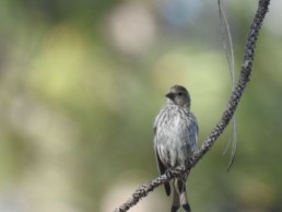
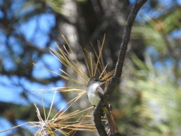
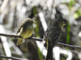
We arrive at camp much later than we or anyone else had expects to another delicious meal of vegetable stew and tortillas. While we slogged through the hot meadow for the second day in a row, James and Whit played it smarter, snapping birds around camp. Notable additions to the inventory include: Pine Siskin, Ash-throated Flycatcher, Black-throated Gray Warbler, Pacific Slope Flycatcher, and Anna’s Humminbird. They even spied a coyote drinking from the creek! Heaven. We spend a well-earned lazy afternoon on field notes and a brief trip back to the fishing hole. I catch a 6” trout on James’s 6 wt. rod with a nymph. A real fighter.
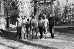
Later, we recreate some of the more amusing photos from Carpenter. His scrapbook photo diary (he evidently never published it) has portraits of party members with nicknames like “Alkali Ike,” “The Ant,” and “the Sluggard.” These have become running jokes on our trip, partly because one photo featuring Alkali Ike and a man named “Pike” look for all the world like James and John. Whitney of course is “the Ant” to Devon’s “Sluggard.” With so many historical analogs to choose from, from field scientists like Lamb and Borell and Huey, to explorers like Ant, Sluggard, Mike, Ike, and the Pomona College English professor Dr. McCully, I can’t help thinking that walking into these mountains is like re-telling an old story. We’ve got some new transportation and gear and research questions, but we’re carting these along on a well-beaten track of history. For the story to change radically, the landscape would have had to change.
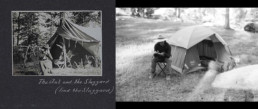

Speaking of analogs, we joke with Devon, the youngest of our party, that an equally good precedent for him is John, the “poor kid” along with Laurence Huey in 1923 who spent the trip “sobbing and sobbing” for homesickness (6/14/1923). (Apparently Devon, a strapping college baseball player, can shoulder just about any amount of teasing.) We hope none of us has her or his historical analog in Pingree Osburn.
We finish the day’s photographic adventures with a group shot around camp.
Dinner of stew and beans and fresh tortillas—our food supplies did rather well, holding out for the duration. I’m in bed by 8pm, exhausted. Tomorrow we head back to Rancho Meling.
